
A claim file needs to show the roof, and a ladder shows one slope at a time. A drone shows the whole property: every roof facet, every side of the structure, the yard, and the damage in context. LossMap is how 1st Choice Living puts that view in the file. It runs as its own brand with its own ordering site.
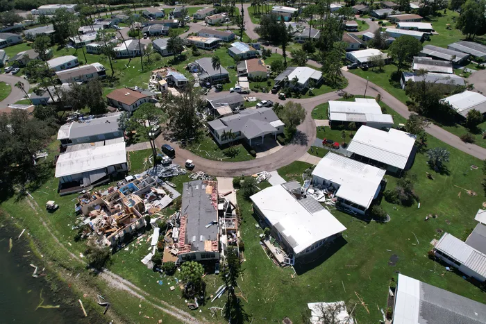
What LossMap delivers
Every shoot follows the same plan: the roof, oblique views, close details, the damage, and video, so files stay consistent from one property to the next. Packages build on each other:
- Roof only. A top-down orthomosaic of the roof, oblique aerials from the four cardinal directions, and roof facet and ridge detail.
- Standard Residential. Everything in the roof package, plus exterior 360 views, yard context, gutter, fascia, and soffit detail, and unedited video.
- Full Property. Built for severe damage and total losses, with a larger photo set, longer unedited video, and an annotated PDF available.
- Commercial. Multi-building and large-acreage sites, with flat and commercial roof orthomosaics, photo sets scaled to the property, recurring project scans, and thermal imagery available. Quoted per site.
The result is a branded web gallery tied to the property, with photos organized by section and a one-click download of every file. The gallery has a permalink, with an optional password, that can be forwarded to adjusters, underwriters, or contractors.
LiDAR 3D scanning is in development and is not available to order yet. The plan is a baseline scan of a property, then a re-flight after damage for a before and after comparison you can explore in a browser. Read about LiDAR on LossMap
How ordering works
Enter the property address, choose a package, and pick a preferred date. Pay by card or order against an adjuster account. A vetted pilot in that market is assigned and flies the shot list, and the gallery is delivered online. Flights need safe weather; if weather holds up a shoot, it is rescheduled at no cost. Adjuster and carrier accounts can use team accounts with shared billing, bulk prepaid credits, and net-30 terms.
Who uses it
How it fits a placement
When we place a travel trailer on a family’s property, our team documents site conditions when the unit is set and again when it is picked up. A LossMap shoot adds the view from above: the roof and exterior at the start of the file and, if you order a second shoot, the state of the property later on. The same named contact who runs the housing can order the shoot, so the aerial record and the placement record land in the same file. Each 1st Choice Living brand is also available on its own, so you can order LossMap for a property whether or not we are housing the family there.
The pilots
LossMap works with vetted local pilots. Every pilot holds an FAA Part 107 remote pilot certificate and carries commercial drone liability insurance, and LossMap verifies credentials at onboarding and checks renewals on a schedule. If you are a certified pilot and want to fly LossMap shoots, apply on the LossMap pilot page.
FAQ
What do I get from a LossMap shoot?
Drone photos and video of the property, flown to a set shot list that covers the roof, each side of the structure, close details, and the damage. Everything is delivered in an online gallery tied to the property, with a download of every file and a link you can share.
Can the gallery go to the carrier or a contractor?
Yes. Each gallery has a permalink, with an optional password, that can be forwarded to adjusters, underwriters, or contractors.
Do I need a 1st Choice Living placement to order?
No. LossMap is available on its own and is ordered online. If we are already housing the family, your 1st Choice Living contact can order the shoot for you.
Working a claim? See For adjusters and carriers